Celebrating 15 years
as a grassroots voice
for the natural environment!
Celebrating 15 years
as a grassroots voice
for the natural environment!
 is seen at the foot of Scenic Brookside Road")
Historic Ware House (ca. 1720) is seen at the foot of Scenic Brookside Road
The entire Brookside Area is filled with history: Natural, Native American, European and Colonial. Brookside Road itself is an Ancient Way and Scenic Road.
Townspeople use the road daily and derive deep meaning from its beauty and historic landscape.
An Historical Inventory was commissioned by the Wellesley Historical Commission and submitted to the Massachusetts Historical Commission. You can find the report here.
Here's some of what the inventory uncovered:
The Brookside area derives much of its distinctive character from a long history of activity in the Rosemary Brook valley linked to 17th century Native American settlement, European settlers, agriculture, small-scale industry, municipal institutions and private organizations.
Until the last quarter of the 17th century, the Brookside Road Area was "known and claimed by colonials" but primarily used by native people associated with the Rev. John Eliot's praying town at South Natick. Robert Ware (d. 1699) grandfather of Ephraim Ware of 200 Oakland Street ... had land granted to him, including territory on Rosemary Meadow Brook (sic) and near Maugus Hill, both within the present boundaries of Wellesley.
Maugus Hill in Wellesley derives its name from natives John and Sarah Magus [sic], whose habitation, depending on the season, also reportedly included the Brookside Road Area, specifically a spring south of Oakland Street near the (later) intersection with Brookside Road.
The public way of Brookside Road at was laid out in 1720-1721. The winding path of the road preserves a layout in place since at least the 1850s.
The Federal Writers' Project of the Works Progress Administration of Massachusetts published a guidebook in 1937 of the Commonwealth's Places and People, issued as part of the American Guide Series.
Centennial Reservation and the MassBay Forest are also Native American ancestral lands with the original network of ancient footpaths that are the basis for the present-day trail system and evoke a connection to the past. These trails lead to Maugus Hill, named after Chief Maugus and his wife, Sarah, who lived in these woods. The site may contain unrecognized cultural features or artifacts.
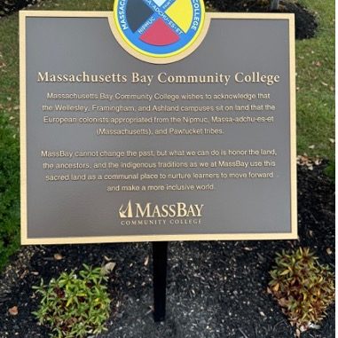
Indigenous History Plaque at MassBay Campus. The memorial plaque reads: “Massachusetts Bay Community College wishes to acknowledge that the Wellesley, Framingham, and Ashland campuses sit on land that the European colonists appropriated from the Nipmuc, Mass-adchu-es-et (Massachusetts), and Pawtucket tribes. MassBay cannot change the past, but what we can do is honor the land, the ancestors, and the indigenous traditions as we at MassBay use this sacred land as a communal place to nurture learners to move forward and make a more inclusive world.”
We need your consent to load the translations
We use a third-party service to translate the website content that may collect data about your activity. Please review the details in the privacy policy and accept the service to view the translations.